When time is of the essence and traditional vessel-towed surveys slow you down, Aqua Survey’s airborne magnetometer glider shifts the paradigm. By cruising just 15 feet above the water at 50–60 mph, it swept nearly 70 square miles in only 20 days—what would have taken years on the water was completed in a fraction of the time.
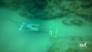
Equipped with a high-sensitivity potassium-vapor magnet gradiometer, the glider maps ferrous anomalies with pinpoint accuracy. From unexploded ordnance and shipwrecks to buried pipeline routes, it delivers clear magnetic anomaly maps that guide safe excavation and engineering decisions.
Map ferrous metals buried in large, near shore areas in record time. It’s what we do.
 Watch “Airborne Mag Survey”